
William B. Thompson:
Vision-Based Navigation in Unstructured, Outdoor Terrain
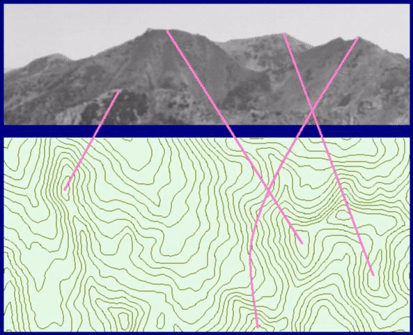 Matching Views to Maps
Navigation in outdoor terrain is difficult due to a lack of easily and uniquely identifiable landmarks. Working as an interdisciplinary team of computer scientists and perceptual psychologist, we have developed a model of the process by which current location can be determined from views of the environment and maps representing topographic information. Laboratory and field studies have yielded information about the strategies used by highly expert map readers, computational analysis has confirmed the utility of these strategies and provided insights into the reasons for their effectiveness, and computer simulations have demonstrated the adequacy of the model on real data.
360 degree panorama images from the Wastach Mountains:


Selected publications:
W.B. Thompson, C.M. Valiquette, B.H. Bennett, and K.T. Sutherland, "Geometric Reasoning for Map-Based Localization," Spatial Cognition and Computation , 1(3), 1999.
H.L. Pick, Jr., M.R. Heinrichs, D.R. Montello, K. Smith, C.N. Sullivan, and W.B. Thompson, "Topographic Map Reading," in Local Applications of the Ecological Approach to Human-Machine Systems, J. Flach, P. Hancock, J. Caird, and K. Vicente, eds., Lawrence Erlbaum Associates, 1995.
K.T. Sutherland and W.B. Thompson, "Pursuing Projections: Keeping a Robot on Path," Proceedings of the IEEE International Conference on Robotics and Automation, May 1994.
K.T. Sutherland and W.B. Thompson, "Localizing in Unstructured Environments: Dealing with the Errors," IEEE Transactions on Robotics and Automation, December 1994.
W.B. Thompson, T.C. Henderson, T.L. Colvin, L.B. Dick, and C.M. Valiquette, "Vision-Based Localization," Proc. ARPA Image Understanding Workshop, April 1993.
W.B. Thompson and H.L. Pick, Jr., "Vision-Based Navigation," Proc. ARPA Image Understanding Workshop, April 1993.